Citizen scientists are helping improve UK rivers by profiling aquatic invertebrate communities

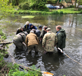
Analysing invertebrate samples to species level – and documenting the communities identified – is yielding rewards locally for the twenty volunteer-led SmartRivers hubs established across the UK. But what does the data tell us and how can it help the 86% of rivers currently failing their ecological targets?

WHAT DO INVERTEBRATE COMMUNITIES TELL US ABOUT WATER QUALITY?
They pinpoint water quality pressures: invertebrate species lists are logged in a central database which generates a water quality ‘scorecard’ for each river site sampled. These results describe the impact of organic pollution, nutrient enrichment, sediment impact, chemical presence, and flow stress based on what invertebrate species are present and absent. Comparing these scorecards along a river system – where water quality deterioration is not always obvious and pollutants are sometimes invisible to the naked eye – allows us to identify water quality pinch points, highlighting where and what the pressures are.
They help us understand climate change: shifts in temperature baselines can lead to changes in the diversity of animals present in a river, altering food web structure and, ultimately, the health of other aquatic organisms such as salmon and trout. Research in Scotland and Wales has already shown that in higher altitude, northern rivers the cold-water loving invertebrates usually present are decreasing due to rising temperatures. One study showed that invertebrate abundance declined by 21% for every 1 degree Celsius rise in temperature.
Sampling allows us to detect invasive species: over 2,000 plants and animals have been introduced to Britain from all over the world. Most are harmless, but 10-15% spread and become invasive non-native species. Warming temperatures and poor water quality can cause ecological disruption that reduces the success of native species and result in non-native invaders establishing more easily. The coverage and resolution of SmartRivers monitoring can help us detect new invasive species, and better understand the spread of existing invasive species.
They provide a robust benchmark: We’ve all seen the headlines about the national crisis our rivers are in. With only 14% in good ecological health, and every single one failing to meet chemical standards, it is clear the status quo is no longer an option. Despite the shocking figures, coverage, resolution, and frequency of national monitoring regimes continues to decline. SmartRivers works to fill this gap, systematically collecting evidence of the problems.
CASE STUDY
Supporting water-friendly land management on the South Esk.
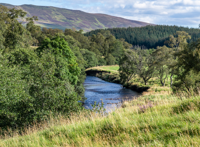
In Angus on the East coast of Scotland, is the South Esk river. An upland river with a catchment area of 564 km2 and a length of 79km, it rises in the eastern Cairngorm Mountains and flows southeast before discharging into the North Sea. The primary land uses in the upper catchment are sheep farming, sporting estates, and commercial forestry, while in the middle and lower catchment, land use is dominated by arable and livestock farming.
This spring, the Esk Rivers and Fisheries Trust are setting up a SmartRivers hub on the South Esk. They are planning to use species-level monitoring to evidence the expected pressures from increasing agricultural practice, predominant across the landscape.
The main challenges facing the South Esk
Volunteers have identified run-off as a significant challenge and contributing factor to the large amount of fine silt particles found in the river. Much of Glen Clova – through which the river flows on its journey east – was a post-glacial lakebed which naturally introduces fine, sandy sediments into the river. These natural deposits are being exacerbated by intensive arable agriculture with minimum buffer zones which results in excess silt entering the river following heavy rainfall. These silts smother vital in-river habitats, altering the ecological balance and adversely impacting the invertebrates and fish within the river system.
How will SmartRivers data help the Esk Rivers & Fisheries Trust target local river management?
The evidence collected by volunteer-led hubs like the Esk Rivers & Fisheries Trust can be used locally to influence land users and encourage management practices that help restore the natural balance of the river’s ecosystem.
Species data collected on the South Esk will be used with upland landowners to employ a ‘slow the flow’ technique, which uses strategic planting of native broadleaf and pine trees on valley slopes as well as in the riparian zone. The data will also support work with farmers in lower catchments to encourage them to incorporate larger buffer areas and to set back river embankments where possible.

Without a strong data baseline, it is extremely difficult to determine the long-term biological impacts of the pressures plaguing our watercourses, or confidently measure the success of actions undertaken to improve them.
Invertebrate data, collected by SmartRivers volunteers, works to fill this gap by systematically collecting evidence of the problems. This evidence supports targeted and responsive local river management and build a national picture of the issues facing freshwater.
Aquatic invertebrate communities’ – and the volunteers who analyse them – are invaluable in our understanding of what’s really happening under the surface. What remains to be seen is if the regulatory bodies responsible for protecting freshwater will listen.
CONTRIBUTORS
Special thanks go to the Esk Rivers and Fisheries Trust for their help in writing this piece and their contribution to the SmartRivers project.
FIND OUT MORE
For more information about how to register your interest in becoming a SmartRivers hub please visit the link below.
Register your interest in SmartRivers
For more information about the South Esk Rivers & Fisheries Trust please visit the link below.


